
Leeds Tube map
Hello visitors! See this update!
Leeds is an amazing city: my favourite place I’ve ever lived. But one thing it does really badly is public transport. We have one massive railway station in the centre of town and then (with a few exceptions) the rest of the city is accessible by unreliable, expensive and unpleasant First buses.
As I have got to know the city better, one thing has kept coming back to me: wouldn’t it be amazing if Leeds had a metro system? So I imagined an alternate reality where the city I love has an amazing and reliable underground railway called Leeds Tube.
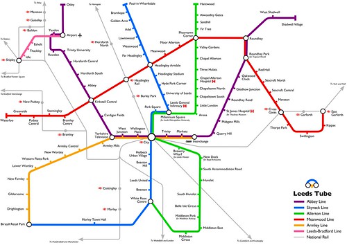
Click to view a larger version on Flickr.
Leeds Tube has several lines that connect the major population centres and attractions, including the Meanwood Line which connects the various settlements in North Leeds that have a very close relationship with one another and the Leeds-Bradford Line that connects the airport with Shipley for onward rail connections to Bradford and its suburbs.
I drew a fancy tube map1 (above) and I also plotted roughly where I think the stations would be on a Google Map (below):
View Leeds Tube in a larger map
How would your life be changed if Leeds had a Tube? What journeys would it help you with? Would you put the stations or lines somewhere else if you were designing it? Let me know in the comments!
Edit: Following some feedback on Twitter, I’ve made a couple of changes to the Beeston area, which I’d been thinking about before but didn’t make, for some reason.
- I’ve released the tube map under an attribution-noncommercial licence, so feel free to print it out or use it yourself for things as long as you credit me and don’t make any money from it. If you’re interested, the SVG source is available too. [↩]
28 Comments
Trackbacks/Pingbacks
- Leeds today: Census, fantasy transport, Feb 14th, incinerators, bikes, M1 and Chinese new year! | Beyond Guardian Leeds - [...] blogger Rich Daley has put together a tube map-equivalent of Leeds, showing “an alternate reality where the city I…
- Leeds Tube map updated – My blog has something to tell you - [...] Leeds Tube map was an unexpected hit on Twitter, and I even ended up being in the Yorkshire Evening [...]
- Leeds: City of Data | Data-Based - […] Daley. His Leeds tube map (above) imagines Leeds with an underground system to rival London’s. He describes his labour…
 Leeds-based non-binary nerd and sewist. I won't break my streak on Duolingo for anyone.
  Delicious
 Flickr
 Goodreads
 Last.fm
 Leeds Beer Quest
 LinkedIn
 Twitter
Fantastic idea,you must have a lot of time on your hands.Rothwell is a highly populated area so maybe you could look at an extension from Hunslet/Middleton or Swillington.
I really don’t have a lot of time on my hands! This map has taken me (on and off) since November to complete.
The east & south-east of Leeds would definitely be an obvious additional line, but I didn’t want to overdo it in the beginning!
What a great idea. I can’t help thinking though that the stations in the city centre are too closely spaced. What you gain by increased accessibility you lose by slower speeds. Had you thought of being true to the form of Harry Beck in London and using 45 degree angles?
I was going for a similar sort of spacing to how stations are spaced in central (e.g.) Berlin, Paris or Barcelona. I think it’s OK for the trains to move a bit slowly through the centre because they’re going to get a lot of footfall in those parts. Your mileage may vary (pun intended).
I did start with 45-degree angles, but it didn’t really look very good. I’d be interested to see if someone can pull it off. The SVG is available if you want to have a play in Inkscape!
Fantastic. Really gets you thinking what could happen if we ever got parity on public transport spending.
I’ve worked at the airport for over 12 years and would love the links you suggest.
As a native loiner I love the idea of course; especially a decent service to the airport (part of that could run overground). But I’ve always heard that the soil is all wrong, and apparently we’d need to find about £220m a km from somewhere. Overground seems to be the only practical solution; I always love the suspended and cable cars in Germany, a lot more fun than ugly trolleybuses.
Have you seen this pic of City Square?
Yeah – I’ve even heard that Beeston Hill is built on top of a (still wet) lake. Of course, in a world where money is no object such as my alternative reality, one just has to dig deeper! £220m/km does sound pretty steep, though!
I’d never seen that cutout of City Square – it’s awesome! I knew that historic parts of City Station are underground and inaccessible to the public.
I’m with Peter Smith above re Rothwell. 30,000 souls more or less would be a good catchment – it is LS26 after all, even if the Leeds councillors seem to forget as well. Also the old Stourton P&R which has cropped up in both SuperTram days and with the FTL.
BTW, in terms of its vast expense, Crossrail 1 is about £15bn, that would get us about 68km/42 miles of Metro even at £220m/km. Include Crossrail 2 at another £30bn and that’d be 205km/127 miles of the Leeds Tube – probably enough track?
Love it!
Tried to do something vaguely related myself – took ages: http://www.flickr.com/photos/bradford1/6733170427/
That’s awesome. Extending it to the whole of West Yorkshire would be even more amazing!
Nice, very nice. I’d add a Stainburn Parade stop to the Allerton line and a Carr Manor Station to the Meanwood line at the junction of Carr Manor Crescent and Stonegate Road. Would be tempted to put in a connecting spur from the Carr Manor station into Millenium Square, via Scott Hall Road, with stations at Stainbeck Road, Stainbeck Lane and Potternewton Lane.
I guess the thing is, there is no reason why we couldn’t have exactly this network but with decent, clean and policed over-ground buses, running on dedicated bus lanes. And when I dedicated I mean a continuos piece of roadway to which no other vehicles can get onto, period. Buses are seen a 2nd class travel because they are often dirty, not that cheap, inhabited by an unpleasant minority of antisocial types, not that quick (becuase bus lanes are not continuous) and (my personal hate) you can never see out of the steamed up windows! This could all be changed though, and for much less money than an underground system.
I think you’re right, and I think with council intervention things can be changed (like the Leeds-Bradford “hyperlink” service). The trouble is, right now, First (and the other bus operators to a lesser extent) are not in the slightest bit interested in providing a good service – they only do it when they’re forced to by the council.
Dedicated bus lanes would be amazing too!
Had a go for York – it’s a bit smaller 😉
http://dl.dropbox.com/u/71095650/metro%20v2.jpg
I love it! As a teenager I used to take the bus from Wigginton to York 6th Form College every day… how much better a tube would have made it!
I also love that you’ve reopened Haxby National Rail station. That’s a realistic goal and one that would revolutionize trips home!
Haha, but of course! What’s the point of designing a multi-million pound fantasy rapid transit system if you’re not going to reopen the odd closed rail station?!
Hopefully it will get reopened in the real world as well – been hearing some positive noises
Love it, but I noticed that East End Park and lots of East Leeds locations have been missed out! We’re part of Leeds too and have wonderful communities! 🙁
Yes – I’ve received a lot of comments about East Leeds. I am less familiar with that part of Leeds but I’m going to have a go at putting a line in that covers that area.
Awesome! Thanks so much 🙂 I was planning to make this my desktop wallpaper (one can dream of this being reality), I’ll wait for the new version.
oh how I wish there was a leeds tube, it would be fantastic, this is a brilliant map and so interesting
Great map, was wondering what programme/software you used to create the map?
I just used Inkscape, which is a little open-source SVG editor.
Ok thanks, I’ve had a paper map down for ages for transport in Leeds. I’ll have a go at making it on the computer then.
Can I buy this somewhere?
It’s released under a Creative Commons licence so you are welcome to print it yourself. But it’s a good idea for me to provide it for sale – keep an eye on this blog!
This is fantastic. With all this northern powerhouse talk of late, perhaps a scheme going towards this is actually what would get the cogs turning.
I it were up to me I would extend east from Harewood out to Collingham and Wetherby, but this would still be brilliant if we had this
Our councillors in Leeds are useless when it comes to getting money from central government. When compared to other large UK metropolitan areas Leeds is way behind. Why is central government so biased against our city? All the major UK conurbations except Leeds have a modern transport system. Our councillors instead of meekly taking a begging bowl down to Westminster should take the mace, brandish it & beat the table hard to demand that our business rates go to building a proper tube system for Leeds. To hell with consultation schemes which serve no purpose but to enrich those who are appointed to be on such a committee. Trams, trolley buses, guided buses are merely playing with the situation. If third world cities can afford an underground system then surely Leeds can be brought into the 21st century.