
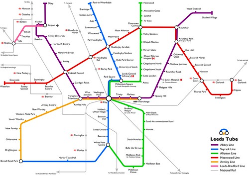
Leeds Tube map updated
Update: you can now buy the Leeds Tube map as a poster for your wall! Hello visitors! See this update for v3 of the map! My Leeds Tube map was an unexpected hit on Twitter, and I even ended up being in the Yorkshire Evening Post! I also received some feedback from people who would like to see my fantasy tube support more of the population centres in Leeds. Some of the feedback was very constructive so I’ve taken the time to update it with two new lines, the East Circle, connecting settlements in East Leeds, and the West Line that connects Armley and Bramley with the rail network. I also updated the Google Map to show the real1 locations of these stations. View Leeds Tube in a larger map As before, this is released under an attribution-noncommercial licence,...
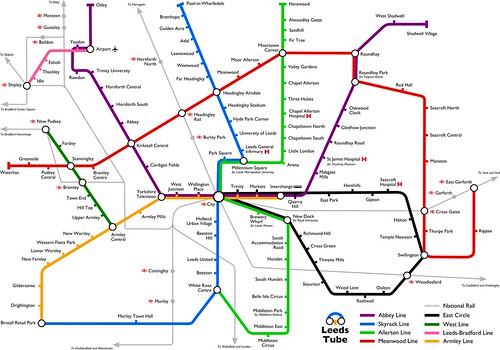
Leeds Tube map
Update: you can now buy the Leeds Tube map as a poster for your wall! Hello visitors! See this update! Leeds is an amazing city: my favourite place I’ve ever lived. But one thing it does really badly is public transport. We have one massive railway station in the centre of town and then (with a few exceptions) the rest of the city is accessible by unreliable, expensive and unpleasant First buses. As I have got to know the city better, one thing has kept coming back to me: wouldn’t it be amazing if Leeds had a metro system? So I imagined an alternate reality where the city I love has an amazing and reliable underground railway called Leeds Tube. Leeds Tube has several lines that connect the major population centres and attractions, including the...
 Leeds-based non-binary nerd and sewist. I won't break my streak on Duolingo for anyone.
  Delicious
 Flickr
 Goodreads
 Last.fm
 Leeds Beer Quest
 LinkedIn
 Twitter