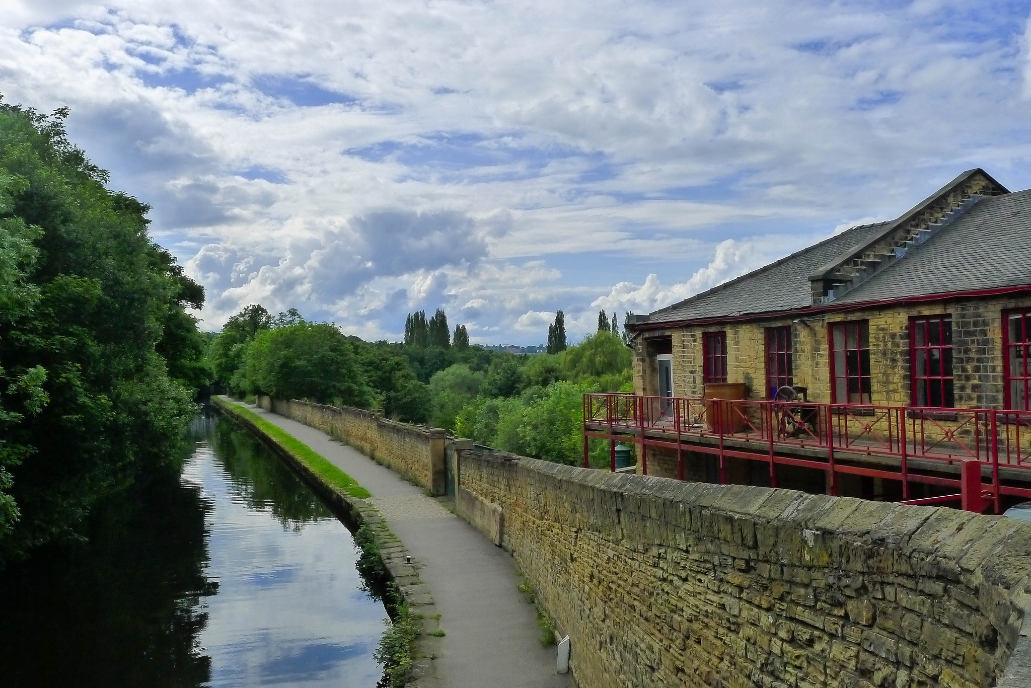

Rivers of Yorkshire
When I think about the locations of towns and cities in Yorkshire, I tend to think in terms of the railway maps. This gives a distorted view that connects Leeds with Huddersfield and Shipley with Ilkley.
A more geographically sensible way to look at things would be to think in terms of the major rivers of Yorkshire. In school I remember learning “SUNWACD” as a mnemonic for remembering the order in which major rivers drain into the Ouse but I didn’t have a good visual picture of how they were laid out.
So this afternoon I spent some time drawing a public-transport-style map of the major rivers in Yorkshire, and settlements along them.
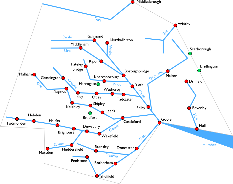
There’s no strong logic to which rivers and settlements I chose: they’re just based on my own knowledge and experience. Major settlements that are not associated with a major river are also marked in green. Note also that I’ve been extremely liberal with the scale and there may be some major inaccuracies here.
If you’re a Yorkshire dweller, how does this stack up with your own perception of where things are?
 Leeds-based non-binary nerd and sewist. I won't break my streak on Duolingo for anyone.
  Delicious
 Flickr
 Goodreads
 Last.fm
 Leeds Beer Quest
 LinkedIn
 Twitter
This is really lovely, and really interesting to see a different way that towns and cities are connected, besides railways and roads.
I would say, though, that I’m uncomfortable with seeing Beverley sitting on the River Hull, but perhaps because I grew up in East Yorks, and it was drummed into us that Beverley doesn’t have a river. I suppose it’s true that the Hull doesn’t run through the centre of Beverley (probably applies to many other towns on here too), but probably close enough to be considered as a transport route between Hull and Beverley.
Yeah. I lived in Beverley and never felt like it had a river either. But if you look on a map it’s right there. The river is 1 mile from the railway station or the Minster so it definitely counts as being associated with the town in a way that rivers are not associated with Bradford (Aire?) and Pocklington (Derwent).
That’s a neat idea, certainly.
In my day(TM) it was `CAWNUST’. Make of this what you may.
Compared to my view of the place, looking at the distances from Selby to Tadcaster and from Bradford to Dewsbury and Halifax, it looks like you have a bit of barrel-distortion centred on Leeds. Well, that’s fair enough too 😉
Not sure it’s centred on Leeds – it’s more a result of following the rivers rather than looking too hard at how settlements on other rivers are placed nearby. North Yorkshire is seriously shrunken because it has fewer major settlements, for example.
The Humber starts at the confluence of the Ouse and Trent, not the Ouse and Don
That’s true. I was applying a little poetic licence.
The Don does join the Ouse at Goole and the Ouse is technically still called the Ouse until it joins the Trent about 6 miles later, but this confluence doesn’t happen on the Yorkshire side of the river so I didn’t label the distinction. There are similar poetic adjustments made elsewhere on the map.
Something I didn’t know until now is that the confluence of the Don and the Ouse at Goole is man-made. Prior to the 1620s the Don joined the Trent and it was diverted to join the Ouse instead.
This page is really interesting, really like your map ideas. Mapmaking is increasingly becoming a central part of my own (art) work. Coming from Barnsley, I’m really interested in both this location and on ideas of how it could function better. Really liked Owen Hatherley’s writings about the ‘hypothetical West Riding Metropolis.
This is a really nice map and very helpful to explain recent flooding. I wish I could find a corresponding one of Lancashire with the Ribble on it , to complete rivers of the Dales
I’m no Yorkshireman, but over sixty years ago my mum told me that “Sam’s uncle never wore any cotton draws”!
(Swale, Ure, Nidd….).
This piece of invaluable knowledge enabled me to know exactly where I was when driving down the A1 from Edinburgh to the South, but recent road improvements have not replaced the river signs on their bridges.
Sat nav is just not the same!
Hi Rich,
Your map will be my starting point for finding Yorkshire river systems to plan a fly fishing holiday in 2018.
Thanks,
Kind regards
Peter, from The Netherlands
I’m very happy to hear it has been helpful! And welcome to Yorkshire!
Can you tell me where the River Ouse starts in Yorkshire? Is it at Boroughbridge or further south where the Nidd joins to the
Ouse. I have been trying to find a clearer map from where the
Ouse starts and where it joins the Humber?
Thanks for any help you can give or tell me where I can get
a clearer map with the names of the rivers and where they join.
Hi Shirley
The Ouse is actually the same river as the Ure, but it’s only known as the Ouse after the confluence with “Ouse Gill Beck” (not pictured on my map) at Linton-On-Ouse.
The Ouse becomes the Humber when it merges with the Trent (also not pictured) at Faxfleet.
There are lots more details on the Wikipedia page: https://en.wikipedia.org/wiki/River_Ouse,_Yorkshire
Hi Rich. This page helped inspire a series of bike trips I’ll be making in 2018 along Yorkshire’s major rivers. (Swale, Ure, Nidd, Wharfe, Aire, Calder, Don, Derwent.)
Among developments this year are a new mountain biking trail along the Swale, opening in May, and the recently relaunched ferry across the Ouse between Nun Monkton and Beningborough Hall.
I’ll be blogging about the trips at http://yorkshireridings.blogspot.co.uk/p/about-yorkshire-ridings.html
Amazing! Thank you for sharing and I’m very happy to hear this was useful!
Great map, very simple, answered all the questions my wife and I were discussing this afternoon! Thanks.
So happy it was helpful!
I agree, great map. A question -is the Humber a river as well as an estuary? It’s never been clear to me.
My understanding is that the estuary begins exactly at the confluence of the Ouse and the Trent so there is no “river part” to the Humber. Supposedly in prehistoric times it was a river but no longer.
I should like to send you an old map which you might find of interest, if you could contact me direct?
SUNWACD – wow, you’ve just brought back memories of a geography lesson 50 years ago. Thank you. Great map too, it now makes sense 50 years later!
I’ve just found your very interesting river map of yorkshire. We live in Hull and its always fascinated me just how much water flows out of the Humber from such a huge area of the north of England. If you include Lincolnshire, Nottinghamshire, Derbyshire etc., its a colossal volume!
Thanks! Yeah it’s pretty extraordinary isn’t it? This map isn’t even including the Trent and all its tributaries (except the Don, which was originally a Trent tributary and artificially routed into the Ouse).
I googled SUWACT as I was discussing rivers of Yorkshire with my Dad and said I could still remember them from school, so I googled and look at you! you have drawn the map…I also seem to have not quite remembered the acronym either, but hey ho…Thanks for the memories and the map looks good too
Excellent. Just spent a while trying to fnd something like this that shows the relationships between teh rivers and what flows in to waht.